Friends of Putnoe Woods and Mowsbury Hillfort
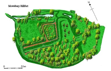
Mowsbury Hillfort
Rising commandingly above the driving range at Mowsbury Golf Course is Mowsbury Hillfort LNR. As its name suggests it contains the remains of a hillfort, one of only 10 univallate hillforts in Bedfordshire, that is a single line of defences, one bank and ditch and the best preserved.
From pottery fragments the hillfort has been dated to the early Iron Age and was made up of wood and clay. It is thought to have been destroyed by a fire hot enough to bake the clay. Orange fragments of the baked clay are thrown up at the entrances to some of the rabbit burrows that dot the site. The site has not been excavated except for some archaeological trenching in 1971 that comfirmed the presence of a single ditch encircling the tip of the spur.
Traces of possible hut circles have been found in the form of a circle of cobbles.
After the fire, pottery fragments show that the hillfort was again occupied in the later Iron Age and into the Roman period, probably as a small farmstead.
The next lasting mark made on the landscape is in the medieval period when a rectangular moated site, with two 'islands', an inner and an outer one, was developed. A wooden bridge would have allowed people to cross from the outer to the inner island. Parts of the moat may have reused the ditch of the original hillfort as part of the defensive structure and part was also adapted as a pair of fishponds for raising fish as a food source. The moat was filled with water, fed by a leat stream (an artificial watercourse or aqueduct dug into the ground).
The medieval site has been identified with the Manor of Morinsbury, mentioned in various documents before 1465. The name may have been retained as "Morsebury" a 16th century field name, which included the area of eathworks and presumably devolved to the present name of Mowsbury.
Morinsbury Manor, orginated in the possessions of Ralph Morin, who held land in Ravensden between 1195 and 1207. The ownership then passed to the Tyringham family. Geoffrey Tyringham owned the land towards the end of the 13th century and then Roger Tyringham between 1302 and 1346. The next owner, John Tyringham leased the property in 1405 to John Prior of Newnham for a term of forty-four years who died in 1416, the manor at the termination of the lease reverting back to John Tyringham who died in 1465, and was succeeded by his son, another John, but after this date there is no further mention of this manor except though traces of it that may be found in the name of Moresbury, a field owned by the Gostwicks in the middle of the 16 century, which included the earthworks, consisting of a mound and moat, now called Morsbury or Mowsbury Hill. The site boundaries have remained the same since enclosure in the 18th century. It is likely to have been used for grazing, raising crops and other forms of agriculture since the medieval period. Traces of ridge and furrow systems can be seen. In a map from 1778 the moated site is marked as a 'Milking Yard'.
A map dated 1884 shows what is now the Golf Course was a rifle range and the western side of the moat had silted up. The hillfort itself is marked as woodland. To the west of the site were brickworks.
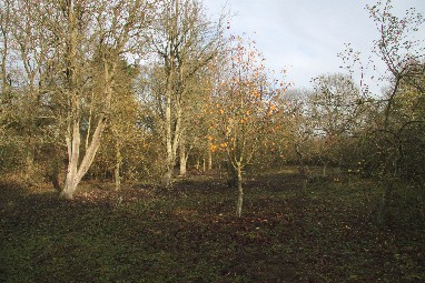
By 1926 the woodland had been cleared and an orchard planted, one of three on the site. This orchard has been neglected for many years apart from annual mowing of the grass surrounding the trees. Recently work has begun to knock back scrub encroachment and to prune the trees to improve their health. Some further fruit tree planting took place in 2000. There is also evidence for an old neglected orchard of plum trees at the western end of the site and another neglected orchard near the remains of a hedgerow at the southeast edge of the site.
By 1926 the nearby brickworks were disused.
A photo taken in 1946 shows the area now called the Courtyard Meadow as clear. Hundreds of orchids flower in this meadow each spring, scrub encroachment has reduced this area significantly. The meadow is mown and raked off each year to maintain the wildflowers and some of the scrub has been knocked back.